Thursday, December 31, 2015

Hooker Valley in the grey

Somewhere around midnight I woke and unzipped my tent so I could look at the stars. There was a little cloud, but the stars shone out brightly, and seemed so much larger than 'usual'. But by the time I woke, the cloud was hanging down from each mountain and hilltop. Regardless, it was time for my Hooker Valley walk up to where you could see the glacier face, so I packed my raincoat, plenty of water, my 'lesser' camera, and started walking.

I retraced my steps from yesterday. I was excited to see the Mt Cook Lily flowering in places. (Or is it a giant buttercup? - must check.)

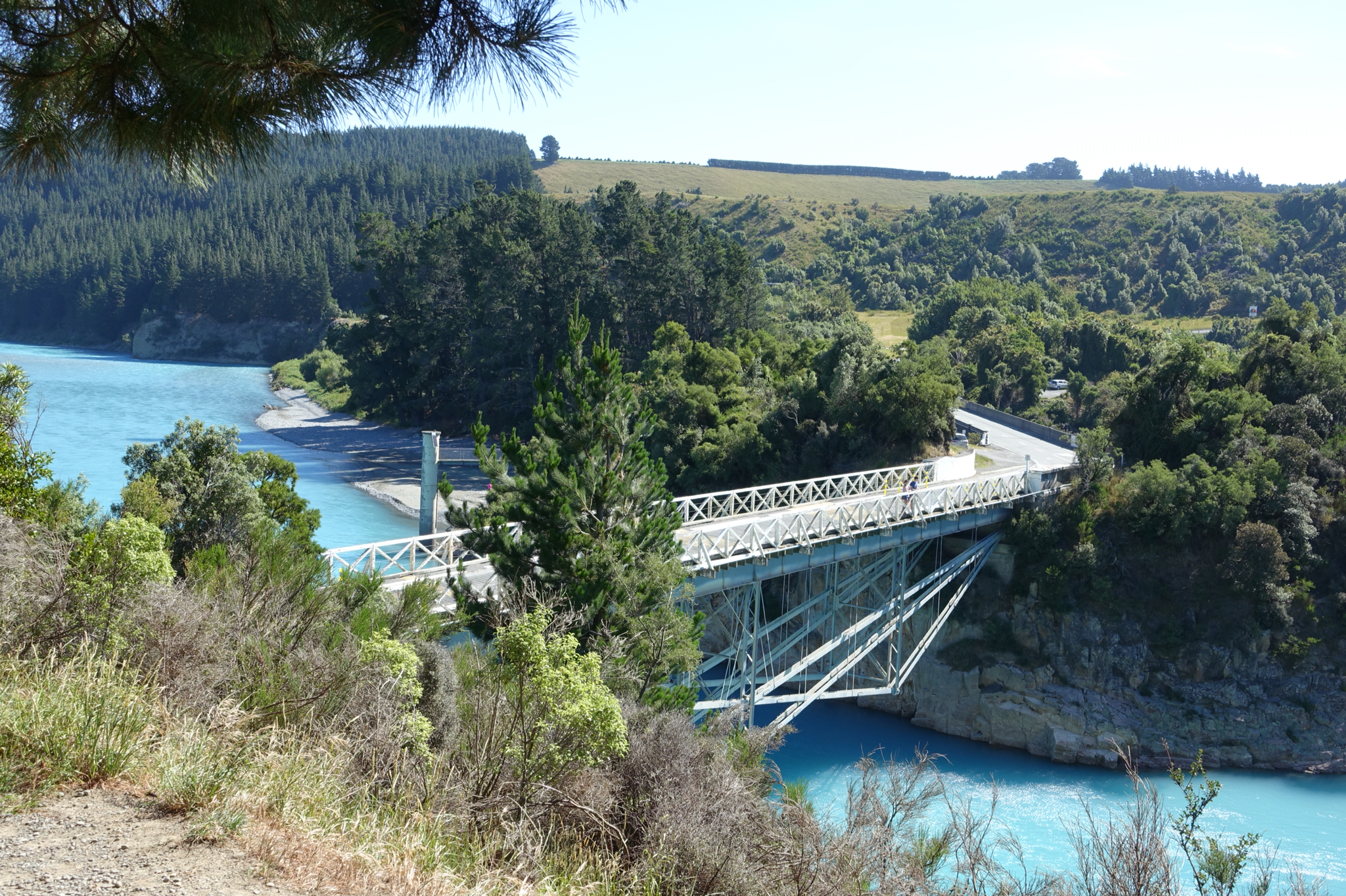
I loved seeing this little bridge and shelter ahead, and it stood out from the overcast grey.

You can see behind it how fragile the shattered rock sides of the mountains are.

Here is the mountain stream that passed below the little bridge.

Up past this you could catch glimpses of Mt Cook, and it looked like the cloud was lifting, and sunshine might break through. But such was not to be: the cloud soon lowered, so I was very glad I took some shots.

There was yet another exciting bridge to cross, the Upper Hooker.

After that there was a relatively short walk to the lake where you could see the terminal face of the glacier. Again I was shocked by how very far it had retreated.

If you ever find yourself in this area, a morning walk means you have the peaceful luxury of the path nearly to yourself. I met hardly anyone on the way up, as it seems like those walking in guided tour groups start the morning later. In this photo you might see a small Aaron, a fellow Kiwi. Yes Aaron, my camera was found!

After my walk it was 11.30 or so, and I headed up to the DOC office to see if my good camera had been turned in. Unfortunately the answer was no, so it seemed like I had truly lost it for good, but they assured me they had my details and would ring if it turned up. They were as good as their word. I drove off to Twizel, turned on my phone, and there was a message to say an Alpine Guide had found a camera and left it at the Hermitage reception. I could scarcely believe it could be mine, so decided to ring and check the description. It all tallied, so I turned around from Twizel and sure enough it was my camera at the desk back in Mt Cook...

So now I will just leave you with one last photo, not from my campsite this time. After the day's rain, the thought of a cabin was tempting. As it turned out, when I arrived in Omarama, they had no tent sites left at this place, but one last cabin room. The bed is so soft that after ten days on a mattress on a tent floor, I am not sure I will easily sleep in it!!! So here today, is the view from my cabin... Some exciting hills in this area, which is a famous area for gliding. So, some more exploration tomorrow...


Hooker Valley Walk in sunshine

It was wonderful to arrive at Mt Cook in sunshine, and it brought back memories of a Hooker Valley walk here in extreme heat some 25-30 years ago. Then the camping ground was further down the valley, and the glacier was much further down as well, filling the valley where moraines now lie 'abandoned' as the glacier has made its dramatic retreat.

I checked out whether there were camping spaces, and there were ample, so it seemed like this might be my stopping point for the evening. The views were stunning.

I wasn't sure how far I would walk this hot afternoon, but I made a start.

Soon there was a large stone with a plaque to commemorate the first woman, Freda du Four, who had climbed Mt Cook in 1910. Her original photo at this point showed her in very feminine climbing gear: how amazing she could do it thus dressed.

Just past it was a memorial to climbers who had lost their lives in the area. An old tramping club friend had died here, so it seemed like a suitable pilgrimage to climb up to it.

There were some clear views of Mt Cook near this point and I am glad I took photos, as it couldn't be seen the next day.

It didn't take long to get to a viewpoint over Lake Mueller, but you had to look high on the mountainside to see where the glaciers still lay.

And down below from there, you could see an exciting swing bridge to cross, so I continued.

It felt a bit scary taking photos from the bridge, but I can imagine it is so much scarier in the wind.

Further on there was another swingbridge, and I walked to a point overlooking it. I had dark trousers on, not suitable for the heat, and my one small water bottle was not enough to drink. So I decided that camping out here, ready for a morning walk, was a grand idea.

Going back in a downhill fashion seemed much faster even on a hot day.

And that my friends is the end of the photos I took with my good camera, until that which became lost was found. The next shot I took with it was checking out whether it still worked, in my car, in the rain, in the car park. And thankfully it did! Thanks to the Alpine Guide who retrieved it!


Rakaia Gorge to Mt Cook 2

Thanks to the anonymous alpine guide at Mt Cook who found my camera, and handed it into the Hermitage Reception, and thanks to DOC for being interested in my lost camera, I can now bring you yesterday's sunny day shots!

I woke at Rakaia Gorge, and enjoyed spending some quiet time enjoying the river view as the day began.

I enjoyed the first part of the drive to Geraldine very much, and it wasn't long before I had joined a NZ traffic jam.

I was surprised by how much flat land I encountered: the South Island is not as hilly all over as I had fondly imagined.

So much of the flat land on this east side of the ranges is very arid though, and a huge amount of irrigation is needed, especially for dairying.

I took the inland scenic route again, and stopped off at an Arundel picnic area near the Rangitata River. It looks so gentle but debris around the piles tells a story of some intense floodwaters.

Gradually some of the countryside started getting hillier.

From Geraldine to Fairlie, I was finally on busy roads, and a local man told me it was everyone heading to Queenstown and Wanaka for New Year.

And from Tekapo I was in the midst of throngs of tourists, many of them from various Asian tour groups.

It was the right decision to go here on Wednesday though: Mt Cook was clearly visible from way back along Lake Pukaki.

I arrived in Mt Cook in full sunshine- which gives a misleading view as I know the mountain conditions here can be so harsh.

After hearing how Farewell Spit is being built up by small particles originating around Mt Cook, I took note of the many hugely fractured, unstable rock faces.

Next post: the sunny Hooker Valley walk


Wednesday, December 30, 2015

Rakaia Gorge to Mt Cook

I was originally thinking I would go down the coast first, but forecast for Wednesday was for showers, so I decided it would be better if I drove to Mt Cook so I could catch it in sunshine. And I did indeed- it was a superb day! And I took some wonderful photos, especially on the Hooker Valley walk. But sad news is... I have lost my good camera! I think I put it down when I did my camp registration, but I haven't found it. Am hoping someone honest hands it into the DOC office or Twizel Police, but I'll check those out tomorrow.

Meanwhile, I just have a couple of campground photos from here at Mt Cook. This is my tent view today! (Taken with my #2 camera.)

This is one of those days when it seems like Mt Cook is a "friendly" place, but I have been here once before when the wind was so fierce I couldn't put my tent up, and retreated 20km down the valley to a backpacker bed. It'll be interesting to see what the morning brings.

I walked quite a bit of the Hooker Valley walk this arvo, but not the lot, as it was quite hot, and I wasn't carrying enough water. So, weather permitting, I will 'repeat' my effort in the cooler morning.

I have a poster on my bedroom wall that must be about 25 years old, of the Hooker Valley. And it is so different now. The first time I came here the camping ground was much further down the valley, and you walked from there to the smallish lake in front of the terminal face of the glacier. You could see chunks of ice floating in the lake. Now the track has been rerouted, and you end up with a viewpoint over the lake. But the glacier has retreated so much- it now ends up on the mountain face. And as you walk the path, to your left you see piles of moraine that were where the valley sides were back then. Anyhow, if my camera turns up, you will get to see the photos I took that makes this all obvious!

I really hit the crowds today at Geraldine, and was very surprised by the amount of traffic on the road from there to Fairlie. But as a local told me, it's all the people heading to Queenstown etc for New Year. There are heaps of people in this DOC camp ground. You had to self-register, and my little tag is by my tent. If it wasn't there, apparently I would be getting a rude awakening in the morning!

Goodnight! People seem to be turning into their tents much earlier here in the mountains.

FOOTNOTE of the happy kind. An alpine guide found my camera and handed it into reception at the Hermitage. More sunny day Mt Cook photos coming in the morning!


Tuesday, December 29, 2015

Reconnecting

My paternal great-grandparents came from Ireland and Scotland to settle in the Charing Cross, Burnham, Kirwee area. I'd visited before, but it was time to reacquaint myself. First I approached Charing Cross via Kirwee. They had a very large block of land on the intersection with Anson's Rd. I wasn't sure exactly how far up Anson's Rd the land went, but every time there was a gap in the huge hedge I took a photo. I was glad to see some sheep in a field, as I know they had sheep. The land is very arid, and also very flat. It is so flat and featureless that it is hard to believe the first of the large Canterbury quakes was centred not far from here.

Next I drove to Darfield to the Catholic Church cemetery, where a group of four ancestors are buried.

And at the Darfield cenotaph, I paid my respects to my great-uncle who died in France in WW1. A lot of work has been done to make the area around the cenotaph look more attractive since I was last here.

Before I left Darfield I had a wee picnic under the shade of a tree, in a park next to the 4Square. Then it as bye bye to the ancestors, and on with the exploring.


Darfield to Rakaia Gorge

From Darfield I took the Inland Scenic Route, 72. It passes through several interesting wee villages and Glentunnel was one of these places that obviously had a very busy time in earlier days of settlement. It had this beautiful little public library building.

And the plaque by the old stables told about the mining past.

I had thought I might do a walk here, but it was across private land, and had a closed sign on it.

I next took a side-road up to Lake Coleridge and saw the power station with all the intake pipes.


My next place to explore was Rakaia Gorge, and when I arrived I decided I would check out the campground. And oh what a view I have for the night!

There were a few people swimming, but the water was way too icy cold for my North Island sensibilities! A paddle on the edge was as close as I got!
There were two bridges, and this one was built a long time back.

There was a walkway which gave some other views from on high.

And you see the wide bend the river took before going more narrowly through the gorge.

Back in the campground I am enjoying the view as the shadows gradually fall on the river. Night all. I think I will be able to do some stargazing this evening from my tent...